
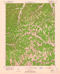
1951 Map of Soldier
USGS Topo · Published 1952About this map
Cumberland National Forest lands dominate this mid-century landscape where the borders of Lewis, Carter, and Rowan counties converge. The rugged topography is defined by an intricate network of drainage branches, including Slab Camp Branch and Millseep Branch, which historically dictated the placement of small rural communities and mountain schools. The Chesapeake and Ohio railroad corridor serves as the primary industrial artery, passing through Haldeman and the area near Enterprise. This transit network is mirrored by the Midland Trail, which follows the contours of the Upper Tygart Creek valley. Genealogists and local historians can trace family locations through several marked burial grounds, such as Trumbo Cem, Patton Cem, and Bradley Cem, alongside community hubs like Bowen Chapel and the Holly School. The map illustrates a period when timber and small-scale agriculture remained central to the economy of these eastern Kentucky hills.
Find a feature on this map
94 named features on this map. Tap any name to fly to it.
Don’t see what you’re looking for? This feature index may not catch every label — zoom into the map to look around manually.
Map Details
Editions of this 1951 Soldier Map
2 editions found
Other maps of this area

1929 · Morehead
USGS Topo · 1:48,000

1935 · Morehead
USGS Topo · 1:62,500

1950 · Head Of Grassy
USGS Topo · 1:24,000

1950 · Wesleyville
USGS Topo · 1:24,000

1950 · Olive Hill
USGS Topo · 1:24,000

1950 · Ault
USGS Topo · 1:24,000

1951 · Cranston
USGS Topo · 1:24,000

1951 · Stricklett
USGS Topo · 1:24,000

1953 · Haldeman
USGS Topo · 1:24,000
1953 · Morehead
USGS Topo · 1:24,000