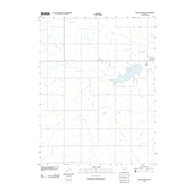
2010 Map of Soldier Creek NE
USGS Topo · Published 2010About this map
Holton anchors the northeastern corner of this Kansas landscape, where the town's early residential and civic layout transitions into a vast network of section-line roads and agricultural tracts. Significant water features including Banner Creek and Elk Creek define the drainage patterns of the region, while the headwaters of Little Soldier Creek and South Cedar Creek traverse the southern reaches. The map captures the placement of historic burial grounds, such as Holton Cemetery on the outskirts of the town and the more isolated Hass Cemetery to the west. This 2010 survey reflects a period of established land use, where the intersection of traditional farm plots meets modern rural infrastructure, documented through a detailed grid of rural routes including 214 Rd and Necole Rd.
Find a feature on this map
21 named features on this map. Tap any name to fly to it.
Don’t see what you’re looking for? This feature index may not catch every label — zoom into the map to look around manually.
Map Details
Editions of this 2010 Soldier Creek NE Map
This is the sole edition of this map. No revisions or reprints were ever made.
Other maps of this area

1888 · Hiawatha
USGS Topo · 1:125,000

1889 · Topeka
USGS Topo · 1:125,000

1894 · Topeka
USGS Topo · 1:125,000

1894 · Hiawatha
USGS Topo · 1:125,000

1950 · Kansas City
USGS Topo · 1:250,000

1954 · Kansas City
USGS Topo · 1:250,000

1956 · Kansas City
USGS Topo · 1:250,000

1960 · Kansas City
USGS Topo · 1:250,000
1960 · Mayetta
USGS Topo · 1:24,000
1960 · Holton
USGS Topo · 1:24,000