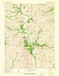
1964 Map of Soldier Creek NW
USGS Topo · Published 1965About this map
The Potawatomi Indian Reservation Boundary and the Old Indian Treaty Boundary both traverse this landscape, marking a complex history of land tenure in northern Kansas. The terrain is defined by the winding paths of Soldier Creek and Cross Creek, which have carved deep valleys into the surrounding uplands. This rural area, surveyed in the mid-1960s, reveals a dispersed pattern of settlement centered around local institutions and agrarian industry. Educational and community life is anchored by locations such as Cedar Hill Sch and Sunny Slope Sch, while several family and community burial grounds, including Olive Hill Cem and Nott Cem, are situated near the ridge lines. Economic activity is evidenced by scattered Oil Wells and various Quarries, illustrating how the local geology supported both small-scale extraction and agriculture during this era.
Find a feature on this map
22 named features on this map. Tap any name to fly to it.
Don’t see what you’re looking for? This feature index may not catch every label — zoom into the map to look around manually.
Map Details
Editions of this 1964 Soldier Creek NW Map
This is the sole edition of this map. No revisions or reprints were ever made.
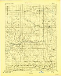
Other maps of this area

1888 · Hiawatha
USGS Topo · 1:125,000

1889 · Seneca
USGS Topo · 1:125,000

1889 · Wamego
USGS Topo · 1:125,000

1889 · Topeka
USGS Topo · 1:125,000
1894 · Seneca
USGS Topo · 1:125,000

1894 · Topeka
USGS Topo · 1:125,000

1894 · Hiawatha
USGS Topo · 1:125,000

1894 · Wamego
USGS Topo · 1:125,000

1950 · Kansas City
USGS Topo · 1:250,000

1954 · Kansas City
USGS Topo · 1:250,000