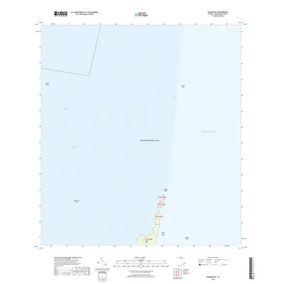
2018 Map of Soldier Key
USGS Topo · Published 2018About this map
Biscayne National Park encompasses nearly the entirety of this marine landscape, which highlights the transition between the shallow waters of Biscayne Bay and the deeper Atlantic Ocean. The map centers on a string of northern Florida Keys, notably Soldier Key and the Ragged Keys, which form a natural barrier broken by tidal channels like Lewis Cut. The northern reaches of Sands Key and the small outpost of Boca Chita Key mark the southern extent of the chain shown here. This 2018 survey documents the intricate shoal and bank systems that define the area's maritime navigation, including the extensive Featherbed Bank and the appropriately named Safety Valve flats. The Intracoastal Waterway provides a clear transit route through the bay side, while landmarks such as Black Ledge and Bowles Bank identify specific underwater features critical for modern maritime charting and local environmental conservation.
Find a feature on this map
15 named features on this map. Tap any name to fly to it.
Don’t see what you’re looking for? This feature index may not catch every label — zoom into the map to look around manually.
Map Details
Editions of this 2018 Soldier Key Map
This is the sole edition of this map. No revisions or reprints were ever made.
Other maps of this area

1947 · Key Biscayne
USGS Topo · 1:24,000

1948 · Soldier Key
USGS Topo · 1:24,000

1949 · Elliott Key
USGS Topo · 1:24,000

1949 · Key Biscayne
USGS Topo · 1:24,000

1949 · Arsenicker Keys
USGS Topo · 1:24,000

1949 · Perrine
USGS Topo · 1:24,000

1950 · South Miami
USGS Topo · 1:24,000
1956 · Elliott Key
USGS Topo · 1:24,000

1956 · Perrine
USGS Topo · 1:24,000

1956 · South Miami
USGS Topo · 1:24,000