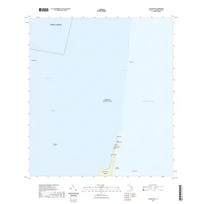
2021 Map of Soldier Key
USGS Topo · Published 2021About this map
Biscayne National Park protects this stretch of the northern Florida Keys, where the waters of Biscayne Bay meet the Atlantic Ocean. The map illustrates a transitional marine environment defined by submerged banks and small islands, including Soldier Key and the Ragged Keys. The boundary of Coral Gables extends into the bay, reflecting the complex maritime jurisdictions of Miami-Dade County. Marine navigation is clearly defined by the Intracoastal Waterway and natural passages such as Lewis Cut, which separates Sands Key from Boca Chita Key. This modern survey documents the bathymetry and shoal patterns of features like the Featherbed Bank and Black Ledge, providing a detailed look at the underwater topography and island chain as it exists in the early 21st century.
Find a feature on this map
16 named features on this map. Tap any name to fly to it.
Don’t see what you’re looking for? This feature index may not catch every label — zoom into the map to look around manually.
Map Details
Editions of this 2021 Soldier Key Map
This is the sole edition of this map. No revisions or reprints were ever made.
Other maps of this area

1947 · Key Biscayne
USGS Topo · 1:24,000

1948 · Soldier Key
USGS Topo · 1:24,000

1949 · Elliott Key
USGS Topo · 1:24,000

1949 · Key Biscayne
USGS Topo · 1:24,000

1949 · Arsenicker Keys
USGS Topo · 1:24,000

1949 · Perrine
USGS Topo · 1:24,000

1950 · South Miami
USGS Topo · 1:24,000
1956 · Elliott Key
USGS Topo · 1:24,000

1956 · Perrine
USGS Topo · 1:24,000

1956 · South Miami
USGS Topo · 1:24,000