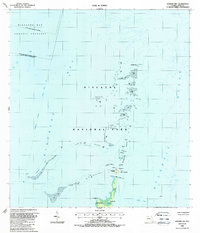
1988 Map of Soldier Key
USGS Topo · Published 1988About this map
Islandia serves as a focal point for this coastal survey, situated among the northern reaches of the Florida Keys. This 1988 map reflects a period of transition and preservation within Biscayne National Park and the Biscayne Bay Aquatic Preserve. The geography is dominated by a chain of islands including Soldier Key, the Ragged Keys, and Boca Chita Key, many of which feature prominent Lookouts and campgrounds for maritime navigation and recreation.
Find a feature on this map
21 named features on this map. Tap any name to fly to it.
Don’t see what you’re looking for? This feature index may not catch every label — zoom into the map to look around manually.
Map Details
Editions of this 1988 Soldier Key Map
This is the sole edition of this map. No revisions or reprints were ever made.
Other maps of this area

1947 · Key Biscayne
USGS Topo · 1:24,000

1948 · Soldier Key
USGS Topo · 1:24,000

1949 · Elliott Key
USGS Topo · 1:24,000

1949 · Key Biscayne
USGS Topo · 1:24,000

1949 · Arsenicker Keys
USGS Topo · 1:24,000

1949 · Perrine
USGS Topo · 1:24,000

1950 · South Miami
USGS Topo · 1:24,000
1956 · Elliott Key
USGS Topo · 1:24,000

1956 · Perrine
USGS Topo · 1:24,000

1956 · South Miami
USGS Topo · 1:24,000