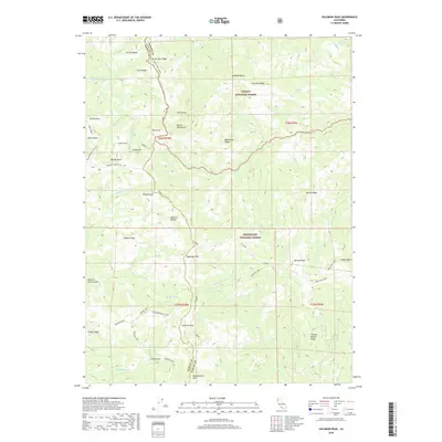
2018 Map of Solomon Peak
USGS Topo · Published 2018About this map
Solomon Peak rises as a prominent landmark along the boundary of the Trinity National Forest and Mendocino National Forest. This high-elevation terrain is characterized by a network of steep ridgelines, including Wrights Ridge, Soldier Ridge, and the long traverse of Devils Hole Ridge. Water sources are scattered across the slopes, from the remote Sulphur Spring and Lazyman Spring to the high-country waters of Kingsley Lake and Minnie Lake. The map captures the rugged backcountry infrastructure of the late 2010s, featuring specialized trails and forest routes like the Ides Cove Loop and the Solomon Peak Cutoff. Named peaks such as Hammerhorn Mtn, Vinegar Peak, and Sugarloaf Mtn define the horizon, marking the divide between the Middle Fork Eel River and Thomes Creek watersheds.
Find a feature on this map
53 named features on this map. Tap any name to fly to it.
Don’t see what you’re looking for? This feature index may not catch every label — zoom into the map to look around manually.
Map Details
Editions of this 2018 Solomon Peak Map
This is the sole edition of this map. No revisions or reprints were ever made.
Other maps of this area

1890 · Red Bluff
USGS Topo · 1:250,000

1894 · Red Bluff
USGS Topo · 1:250,000

1926 · Covelo
USGS Topo · 1:62,500

1931 · Hoaglin
USGS Topo · 1:96,000

1935 · Hoaglin
USGS Topo · 1:125,000

1952 · Covelo
USGS Topo · 1:62,500

1952 · Anthony Peak
USGS Topo · 1:62,500

1953 · Blackrock Mtn
USGS Topo · 1:62,500

1954 · Blackrock Mtn
USGS Topo · 1:62,500

1954 · Yolla Bolly
USGS Topo · 1:62,500