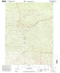
1995 Map of Solomon Peak
USGS Topo · Published 2001About this map
High-altitude ridges and deep basins define this 1995 revision of the northern California highlands, where the boundaries of Shasta National Forest, Trinity National Forest, and Mendocino National Forest converge. The landscape is dominated by the Yolla Bolly Middle Eel Wilderness, a territory of steep relief marked by prominent summits like Solomon Peak and Hammerhorn Mountain. The drainage patterns of the Middle Fork Eel River and Thomes Creek illustrate the topographic divide between the Eel River and Sacramento River watersheds.
Find a feature on this map
52 named features on this map. Tap any name to fly to it.
Don’t see what you’re looking for? This feature index may not catch every label — zoom into the map to look around manually.
Map Details
Editions of this 1995 Solomon Peak Map
This is the sole edition of this map. No revisions or reprints were ever made.
Other maps of this area

1890 · Red Bluff
USGS Topo · 1:250,000

1894 · Red Bluff
USGS Topo · 1:250,000

1926 · Covelo
USGS Topo · 1:62,500

1931 · Hoaglin
USGS Topo · 1:96,000

1935 · Hoaglin
USGS Topo · 1:125,000

1952 · Covelo
USGS Topo · 1:62,500

1952 · Anthony Peak
USGS Topo · 1:62,500

1953 · Blackrock Mtn
USGS Topo · 1:62,500

1954 · Blackrock Mtn
USGS Topo · 1:62,500

1954 · Yolla Bolly
USGS Topo · 1:62,500