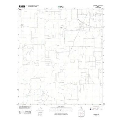
2010 Map of Somerset
USGS Topo · Published 2010About this map
Somerset and the small community of Bexar anchor this South Texas landscape, defined by a transition from traditional rural homesteads to industrial resource extraction. The Somerset Oil Field is a central economic feature, highlighting the region's long-standing connection to petroleum production. This industrial presence is woven into a landscape of family-named roads and markers of early settlement, such as Panteon San Lorenzo Cemetery and Bexar Cemetery. The southern reaches of the quadrangle are shaped by the winding course of the Atascosa River, which provides a natural contrast to the grid-like road network. Roads like Benton City Rd, Somerset Rd, and McConnell Rd connect the scattered residences and ranch lands, reflecting the enduring rural character of this portion of Bexar County despite the surrounding energy development.
Find a feature on this map
51 named features on this map. Tap any name to fly to it.
Don’t see what you’re looking for? This feature index may not catch every label — zoom into the map to look around manually.
Map Details
Editions of this 2010 Somerset Map
This is the sole edition of this map. No revisions or reprints were ever made.
Other maps of this area

1942 · Natalia
USGS Topo · 1:62,500

1953 · Terrell Wells
USGS Topo · 1:24,000

1953 · Macdona
USGS Topo · 1:24,000

1954 · San Antonio
USGS Topo · 1:250,000

1957 · San Antonio
USGS Topo · 1:250,000

1958 · La Coste
USGS Topo · 1:24,000

1958 · Somerset
USGS Topo · 1:24,000

1958 · Thelma
USGS Topo · 1:24,000
1964 · Lytle
USGS Topo · 1:24,000
1964 · Bigfoot
USGS Topo · 1:24,000