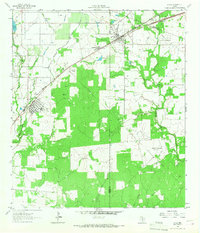
1964 Map of Lytle
USGS Topo · Published 1966About this map
The Missouri Pacific railroad corridor serves as the primary spine for development on this south Texas landscape, connecting the growing settlements of Lytle and Natalia. While agriculture and grazing are evident across the plains, the presence of the Verna-Anacacho Oil Field and the Somerset Oil Field in the southeastern quadrant points to the region's mid-century reliance on petroleum extraction. Local industry is further represented by a Coal Mine and a Gravel Pit situated near the county boundaries.
Find a feature on this map
23 named features on this map. Tap any name to fly to it.
Don’t see what you’re looking for? This feature index may not catch every label — zoom into the map to look around manually.
Map Details
Editions of this 1964 Lytle Map
2 editions found
Other maps of this area

1942 · Natalia
USGS Topo · 1:62,500

1953 · Macdona
USGS Topo · 1:24,000

1954 · San Antonio
USGS Topo · 1:250,000

1957 · San Antonio
USGS Topo · 1:250,000

1958 · La Coste
USGS Topo · 1:24,000

1958 · Somerset
USGS Topo · 1:24,000

1964 · Ghost Hill
USGS Topo · 1:24,000

1964 · Castroville
USGS Topo · 1:24,000

1964 · Devine
USGS Topo · 1:24,000
1964 · Bigfoot
USGS Topo · 1:24,000