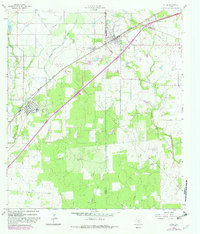
1964 Map of Lytle
USGS Topo · Published 1982About this map
The Missouri Pacific railroad corridor anchors the early 1960s landscape of this South Texas region, connecting the primary settlements of Lytle and Natalia. This area reveals a complex water management system essential for local agriculture, featuring the Natalia Canal, an Elevated Canal, and the Chacon Reservoir. While the towns provide civic foundations like the Calvary Ch and the High Sch, the surrounding terrain is defined by extractive industries. The southeastern portion of the map is dominated by the Somerset Oil Field and Verna-Anacacho Oil Field, while a specific Coal Mine site near the railroad suggests older layers of industrial history. The landscape transitions from the developed town centers and irrigated fields to the winding courses of the Atascosa River and its various prongs and branches.
Find a feature on this map
27 named features on this map. Tap any name to fly to it.
Don’t see what you’re looking for? This feature index may not catch every label — zoom into the map to look around manually.
Map Details
Editions of this 1964 Lytle Map
2 editions found
Other maps of this area

1942 · Natalia
USGS Topo · 1:62,500

1953 · Macdona
USGS Topo · 1:24,000

1954 · San Antonio
USGS Topo · 1:250,000

1957 · San Antonio
USGS Topo · 1:250,000

1958 · La Coste
USGS Topo · 1:24,000

1958 · Somerset
USGS Topo · 1:24,000

1964 · Ghost Hill
USGS Topo · 1:24,000

1964 · Castroville
USGS Topo · 1:24,000

1964 · Devine
USGS Topo · 1:24,000
1964 · Lytle
USGS Topo · 1:24,000