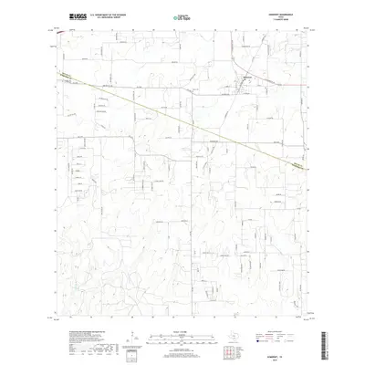
2019 Map of Somerset
USGS Topo · Published 2019About this map
The town of Somerset sits at the intersection of farm roads and historic thoroughfares just north of the Bexar Co and Atascosa Co line. This landscape is defined by the winding course of the Atascosa River and a dense network of country roads named for local families and early transit routes. Significant local landmarks include Panteon San Lorenzo Cem and Bexar Cem, which provide essential points of reference for genealogists tracing the heritage of this region south of San Antonio. The mapping reflects a mix of traditional agricultural parcels and modern residential developments, with major arteries like Somerset Rd, Benton City Rd, and the C W Anderson Loop connecting the community to the broader Texas road system.
Find a feature on this map
102 named features on this map. Tap any name to fly to it.
Don’t see what you’re looking for? This feature index may not catch every label — zoom into the map to look around manually.
Map Details
Editions of this 2019 Somerset Map
This is the sole edition of this map. No revisions or reprints were ever made.
Other maps of this area

1942 · Natalia
USGS Topo · 1:62,500

1953 · Terrell Wells
USGS Topo · 1:24,000

1953 · Macdona
USGS Topo · 1:24,000

1954 · San Antonio
USGS Topo · 1:250,000

1957 · San Antonio
USGS Topo · 1:250,000

1958 · La Coste
USGS Topo · 1:24,000

1958 · Somerset
USGS Topo · 1:24,000

1958 · Thelma
USGS Topo · 1:24,000
1964 · Lytle
USGS Topo · 1:24,000
1964 · Bigfoot
USGS Topo · 1:24,000