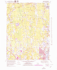
1967 Map of Somerset
USGS Topo · Published 1979About this map
Taunton River and Three Mile River define the eastern edges of this landscape, where the tidal influence at Broad Cove meets the suburban expansion of Somerset and Pottersville. The terrain is characterized by extensive wetlands such as Squannakonk Swamp and Maple Swamp, interspersed with high points like Great Meadow Hill. The 1970s updates, shown in purple, reveal significant development and infrastructure growth around Chestnut Tree Corner and near the Somerset Reservoir. Local history is preserved in small family and community burial grounds, including the Hathaway Cem and Coldbrook Cem, which dot the rural roads between the established villages of Rehoboth and Hortonville. This geography illustrates a transition from low-lying marshlands and swamps to the industrial and residential corridors of the late twentieth century.
Find a feature on this map
81 named features on this map. Tap any name to fly to it.
Don’t see what you’re looking for? This feature index may not catch every label — zoom into the map to look around manually.
Map Details
Editions of this 1967 Somerset Map
2 editions found
Other maps of this area

1885 · Taunton
USGS Topo · 1:62,500

1887 · Providence
USGS Topo · 1:62,500

1888 · Fall River
USGS Topo · 1:62,500

1888 · Taunton
USGS Topo · 1:62,500

1889 · Providence
USGS Topo · 1:62,500

1890 · Narragansett Bay
USGS Topo · 1:62,500

1892 · Narragansett Bay
USGS Topo · 1:62,500

1893 · Taunton
USGS Topo · 1:62,500

1893 · Fall River
USGS Topo · 1:62,500

1894 · Providence
USGS Topo · 1:62,500