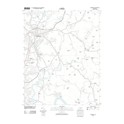
2010 Map of Somerset
USGS Topo · Published 2010About this map
Somerset serves as the focal point of this Pulaski County landscape, where urban development meets the deep-cut topography of the Cumberland River valley. The map reveals a transition from the dense street grids of the city and its neighboring town of Ferguson to the rugged, knob-filled terrain to the east and south. This area is defined by a series of named peaks such as Thunder Struck Knob, Buzzard Knob, and Lick Skillet Knob, which hem in narrow valleys like Blaze Valley and Cabin Hollow. Along the southern edge, the waters of Lake Cumberland occupy the winding river channel near Cedar Grove, while the local infrastructure is highlighted by Somerset-Pulaski County/JT Wilson Field and the University of Kentucky Community College. Family history is preserved in scattered burial grounds including Dutton Cemetery and Love Cemetery, providing a detailed look at the rural settlements and land use in south-central Kentucky.
Find a feature on this map
90 named features on this map. Tap any name to fly to it.
Don’t see what you’re looking for? This feature index may not catch every label — zoom into the map to look around manually.
Map Details
Editions of this 2010 Somerset Map
This is the sole edition of this map. No revisions or reprints were ever made.
Other maps of this area

1890 · Williamsburg
USGS Topo · 1:125,000

1893 · London
USGS Topo · 1:125,000

1894 · Williamsburg
USGS Topo · 1:125,000

1897 · London
USGS Topo · 1:125,000

1932 · Burnside
USGS Topo · 1:62,500

1935 · Somerset
USGS Topo · 1:62,500

1952 · Hail
USGS Topo · 1:24,000

1952 · Dykes
USGS Topo · 1:24,000

1952 · Shopville
USGS Topo · 1:24,000

1953 · Frazer
USGS Topo · 1:24,000