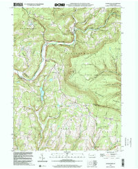
1999 Map of Sonestown
USGS Topo · Published 2001About this map
Sonestown and Muncy Valley sit within a landscape defined by the deep incisions of Muncy Creek and its numerous tributaries. This 1999 topography illustrates a region where timber and transport history remain visible, most notably through the Old Railroad Grade that skirts the southern edge of the Muncy Valley settlement. The mountainous terrain of Davidson and North Mountain is punctuated by local landmarks like the Covered Bridge and the Lookout Tower, reflecting a rural Pennsylvania character where small hamlets like Lungerville and Biggerstown are connected by winding valley roads. To the south, Beaver Lake and Marsh Run mark a transition into the more dispersed farmstead and church-centered communities such as Franklin Ch, while the vast State Game Lands No 13 preserves the high Huckleberry Mountain plateau.
Find a feature on this map
45 named features on this map. Tap any name to fly to it.
Don’t see what you’re looking for? This feature index may not catch every label — zoom into the map to look around manually.
Map Details
Editions of this 1999 Sonestown Map
This is the sole edition of this map. No revisions or reprints were ever made.
Other maps of this area

1894 · Bloomsburg
USGS Topo · 1:62,500

1927 · Eagles Mere
USGS Topo · 1:48,000

1932 · Eagle Mere
USGS Topo · 1:62,500

1934 · Laporte
USGS Topo · 1:62,500

1935 · Hughesville
USGS Topo · 1:62,500

1947 · Benton
USGS Topo · 1:31,680
1953 · Benton
USGS Topo · 1:24,000

1953 · Hughesville
USGS Topo · 1:62,500

1953 · LaPorte
USGS Topo · 1:62,500

1953 · Eagles Mere
USGS Topo · 1:62,500
Featured Places
- Davidson Township, PA
- Beaver Lake, Penn Township
- Franklin Township, PA
- Penn Township, PA
- Laporte Township, PA