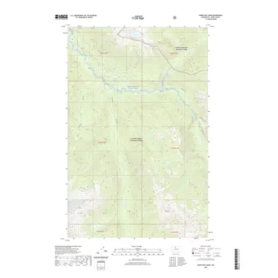
2020 Map of Sonny Boy Lakes
USGS Topo · Published 2020About this map
The Skagit Wild And Scenic River corridor defines this high-elevation landscape within the North Cascades National Park and Mount Baker National Forest. The geography is shaped by the complex drainage of the Cascade River and its numerous tributaries, including the Middle Fk Cascade River and S Fork Cascade River. Notable high-country water bodies such as Hidden Lake, Found Lake, and the sequentially named Lake Number 1 and Lake Number 2 dot the alpine terrain. These features, along with the evocatively named Long Gone Lake, illustrate a glaciated environment where water systems are primary landmarks. The presence of Saddle Point provides a rare named terrestrial navigational marker amidst a network of creeks like Kindy Creek and Sonny Boy Cr.
Find a feature on this map
44 named features on this map. Tap any name to fly to it.
Don’t see what you’re looking for? This feature index may not catch every label — zoom into the map to look around manually.
Map Details
Editions of this 2020 Sonny Boy Lakes Map
This is the sole edition of this map. No revisions or reprints were ever made.
Other maps of this area

1899 · Glacier Peak
USGS Topo · 1:125,000

1901 · Glacier Peak
USGS Topo · 1:125,000

1953 · Marblemount
USGS Topo · 1:62,500

1955 · Concrete
USGS Topo · 1:250,000

1958 · Concrete
USGS Topo · 1:250,000

1962 · Concrete
USGS Topo · 1:250,000

1963 · Sonny Boy Lakes
USGS Topo · 1:24,000

1963 · Eldorado Peak
USGS Topo · 1:24,000
1963 · Forbidden Peak
USGS Topo · 1:24,000
1963 · Downey Mtn
USGS Topo · 1:24,000