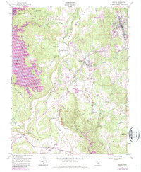
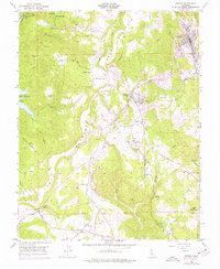
1948 Map of Sonora
USGS Topo · Published 1987About this map
Table Mountain dominates the central landscape of this Gold Country survey, its flat-topped basaltic ridge tracing the ancient riverbeds that once drew miners to Tuolumne County. This map documents a fascinating layered history where 19th-century mining infrastructure meets mid-20th-century water management. Early settlements such as Jamestown, Tuttletown, and Montezuma are surrounded by significant mining operations, including the Harvard Mine and Golden Rule Mine. Literary history is grounded in the terrain at Mark Twain Cabin on Jackass Hill, while the evolution of the landscape is marked by the presence of New Melones Lake and Don Pedro Reservoir. The transition from the era of the Sierra Ditch to the development of modern transport is evident at Yosemite Junction and the Landing Strip near Chinese Station.
Find a feature on this map
39 named features on this map. Tap any name to fly to it.
Don’t see what you’re looking for? This feature index may not catch every label — zoom into the map to look around manually.
Map Details
Editions of this 1948 Sonora Map
5 editions found
Other maps of this area

1889 · Jackson
USGS Topo · 1:125,000

1891 · Big Trees
USGS Topo · 1:125,000

1892 · Jackson
USGS Topo · 1:125,000

1893 · Sonora
USGS Topo · 1:125,000

1894 · Big Trees
USGS Topo · 1:125,000

1896 · Sonora
USGS Topo · 1:125,000

1897 · Jackson
USGS Topo · 1:125,000

1897 · Sonora
USGS Topo · 1:125,000

1897 · Big Trees
USGS Topo · 1:125,000

1898 · Sonora
USGS Topo · 1:125,000