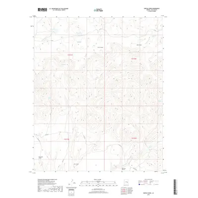
2018 Map of Sontag Creek
USGS Topo · Published 2018About this map
The Blue River carves through this portion of eastern Arizona, defining a landscape of deep drainages and vital water sources within the Apache-Sitgreaves National Forest area. Named topographical features like Bronco Canyon, Black Mesa Canyon, and Bear Canyon illustrate the complex relief of the terrain, while Dads Lookout provides a high-point vantage over the surrounding ridges. For researchers of the local environment and land use, the map documents an extensive network of water improvements essential for ranching and wildlife, including Walker Park Tank, Gimme Tank, and Cattle Guard Tank. Natural hydrology is represented by several perennial sources such as Cienega Spring, White Tail Spring, and Blue River Spring. Access to this remote region is shown via several Bureau of Indian Affairs routes, including Bia RD 1200 and Bia RD 1215, which traverse the southern sections.
Find a feature on this map
25 named features on this map. Tap any name to fly to it.
Don’t see what you’re looking for? This feature index may not catch every label — zoom into the map to look around manually.
Map Details
Editions of this 2018 Sontag Creek Map
This is the sole edition of this map. No revisions or reprints were ever made.
Other maps of this area

1954 · Mesa
USGS Topo · 1:250,000

1957 · Mesa
USGS Topo · 1:250,000

1958 · Mesa
USGS Topo · 1:250,000

1960 · Mesa
USGS Topo · 1:250,000

1964 · Mesa
USGS Topo · 1:250,000

1965 · Sontag Mesa
USGS Topo · 1:24,000

1966 · Brushy Canyon
USGS Topo · 1:24,000

1966 · Natural Corral
USGS Topo · 1:24,000
1966 · Bronco Gulch
USGS Topo · 1:24,000

1966 · Popcorn Canyon
USGS Topo · 1:24,000