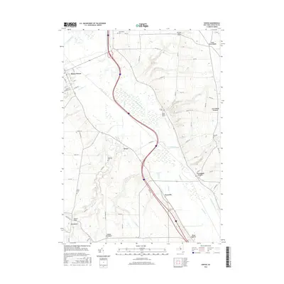
2016 Map of Sonyea
USGS Topo · Published 2016About this map
Canaseraga Creek and its broad valley dominate this Livingston County landscape, weaving through a series of agricultural hamlets and historic institutional sites. In the village of Mount Morris, the street grid extends toward the Genesee River, while the southern reaches of the map are defined by smaller clusters like Tuscarora and Union Corners. The map provides significant genealogical value through its documentation of numerous burial grounds, including the Craig State School Cem near Sonyea and the Dutch Street Cem to the west. Deep drainages such as Wildcat Gully and Mill Gully cut into the rising eastern hills, illustrating the erosion patterns characteristic of the region. This modern survey also identifies local aviation hubs like Merrimac Farms Airport and Seven Gullies Airport, alongside traditional water features like the Tail Race and W Ditch.
Find a feature on this map
67 named features on this map. Tap any name to fly to it.
Don’t see what you’re looking for? This feature index may not catch every label — zoom into the map to look around manually.
Map Details
Editions of this 2016 Sonyea Map
This is the sole edition of this map. No revisions or reprints were ever made.
Other maps of this area

1901 · Honeoye
USGS Topo · 1:62,500

1902 · Wayland
USGS Topo · 1:62,500

1904 · Wayland
USGS Topo · 1:62,500

1904 · Caledonia
USGS Topo · 1:62,500

1904 · Honeoye
USGS Topo · 1:62,500

1905 · Nunda
USGS Topo · 1:62,500

1942 · Dansville
USGS Topo · 1:31,680

1942 · Conesus
USGS Topo · 1:31,680
1942 · Livonia
USGS Topo · 1:31,680

1943 · Mount Morris
USGS Topo · 1:24,000