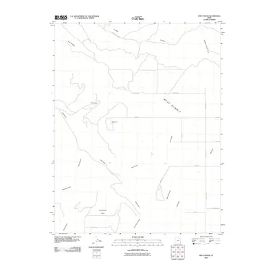
2010 Map of Sop Canyon
USGS Topo · Published 2010About this map
Sop Canyon and its surrounding high plateaus define this corner of San Juan County, illustrating a landscape primarily organized by drainage patterns and rural access roads. The topographic data reveals a network of canyons including East Canyon, South Canyon, and Bear Trap Canyon that carve through prominent elevations such as West Summit and Deerneck Mesa. Historical resource extraction is evidenced by the presence of the Rim Canyon Mine, located near the head of Pine Hollow. Water sources are sparse in this environment, with Sop Spring and the intermittently flowing Dry Wash serving as critical landmarks. A grid-like system of named routes, such as Williamson Fork Rd and Old Summit Rd, provides the modern framework for navigating this remote terrain, connecting isolated geographic points like Iron Canyon Point to the broader regional road network.
Find a feature on this map
27 named features on this map. Tap any name to fly to it.
Don’t see what you’re looking for? This feature index may not catch every label — zoom into the map to look around manually.
Map Details
Editions of this 2010 Sop Canyon Map
This is the sole edition of this map. No revisions or reprints were ever made.
Other maps of this area

1885 · La Sal
USGS Topo · 1:250,000

1886 · Abajo
USGS Topo · 1:250,000

1892 · Abajo
USGS Topo · 1:250,000

1893 · Abajo
USGS Topo · 1:250,000

1954 · Mt Peale 4 NE
USGS Topo · 1:24,000

1954 · Mt Peale 4 NW
USGS Topo · 1:24,000

1954 · Mt Peale 3 NE
USGS Topo · 1:24,000

1954 · Mt Peale 3 SE
USGS Topo · 1:24,000
1954 · Mt Peale 4 SE
USGS Topo · 1:24,000

1954 · Mt Peale 4 SW
USGS Topo · 1:24,000