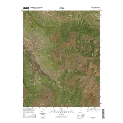
2014 Map of Sop Canyon
USGS Topo · Published 2014About this map
Sop Canyon and its associated water source, Sop Spring, dominate this high-altitude landscape in San Juan County. The terrain is defined by a series of deep drainages and prominent rises, including Deerneck Mesa in the northwest and Three Step Hill to the northeast. The presence of numerous named canyons such as Bear Trap Canyon, Iron Spring Canyon, and South Canyon suggests a complex system of erosion and seasonal water flow, further evidenced by East Canyon Wash and Wild Horse Draw. A network of unpaved corridors, including Williamson Fork Rd, Old Summit Rd, and Bryan Rd, provides access to these remote reaches, tracing the natural contours between West Summit and Iron Canyon Point. This survey captures the topographical character of the Four Corners region before more intensive modern development altered these traditional ranching or grazing lands.
Find a feature on this map
31 named features on this map. Tap any name to fly to it.
Don’t see what you’re looking for? This feature index may not catch every label — zoom into the map to look around manually.
Map Details
Editions of this 2014 Sop Canyon Map
This is the sole edition of this map. No revisions or reprints were ever made.
Other maps of this area

1885 · La Sal
USGS Topo · 1:250,000

1886 · Abajo
USGS Topo · 1:250,000

1892 · Abajo
USGS Topo · 1:250,000

1893 · Abajo
USGS Topo · 1:250,000

1954 · Mt Peale 4 NE
USGS Topo · 1:24,000

1954 · Mt Peale 4 NW
USGS Topo · 1:24,000

1954 · Mt Peale 3 NE
USGS Topo · 1:24,000

1954 · Mt Peale 3 SE
USGS Topo · 1:24,000
1954 · Mt Peale 4 SE
USGS Topo · 1:24,000

1954 · Mt Peale 4 SW
USGS Topo · 1:24,000