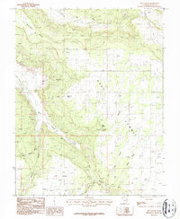
1987 Map of Sop Canyon
USGS Topo · Published 1987About this map
Deerneck Mesa and the surrounding high desert plateaus of San Juan County dominate this mid-1980s landscape. The map reveals a land defined by its deep drainages, including the extensive Sop Canyon, Bear Canyon, and Iron Canyon. While the terrain is naturally isolating, human activity is evident through the industrial infrastructure of the Rim Canyon Mine and various Grain Bins scattered near the southern boundary.
Find a feature on this map
19 named features on this map. Tap any name to fly to it.
Don’t see what you’re looking for? This feature index may not catch every label — zoom into the map to look around manually.
Map Details
Editions of this 1987 Sop Canyon Map
This is the sole edition of this map. No revisions or reprints were ever made.
Other maps of this area

1885 · La Sal
USGS Topo · 1:250,000

1886 · Abajo
USGS Topo · 1:250,000

1892 · Abajo
USGS Topo · 1:250,000

1893 · Abajo
USGS Topo · 1:250,000

1954 · Mt Peale 4 NE
USGS Topo · 1:24,000

1954 · Mt Peale 4 NW
USGS Topo · 1:24,000

1954 · Mt Peale 3 NE
USGS Topo · 1:24,000

1954 · Mt Peale 3 SE
USGS Topo · 1:24,000
1954 · Mt Peale 4 SE
USGS Topo · 1:24,000

1954 · Mt Peale 4 SW
USGS Topo · 1:24,000