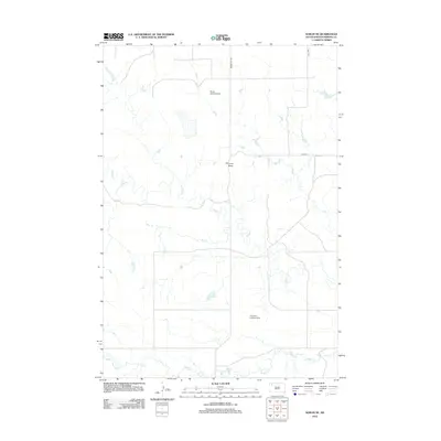
2012 Map of Sorum NE
USGS Topo · Published 2012About this map
Chimney Butte stands as a prominent landmark in this portion of Perkins County, overlooking a landscape defined by the winding paths of Rabbit Cr and its tributaries. The drainage patterns of Bog Cr and Peggy Cr illustrate the hydrological character of the western South Dakota plains. Aviation footprints are visible through the inclusion of the Quaal Landing Strip and the Ike John Landing Strip, reflecting the necessity of private air travel in this expansive rural environment. The road network, including Prairie City Rd, 164th Ave, and 134th St, provides the primary framework for local transit between ranch lands and isolated homesteads. This 2012 survey by the U.S. Geological Survey offers a clear view of the area's topographical relief and human infrastructure in the early 21st century.
Find a feature on this map
9 named features on this map. Tap any name to fly to it.
Don’t see what you’re looking for? This feature index may not catch every label — zoom into the map to look around manually.
Map Details
Editions of this 2012 Sorum NE Map
This is the sole edition of this map. No revisions or reprints were ever made.
Other maps of this area

1954 · Lemmon
USGS Topo · 1:250,000

1957 · Lemmon
USGS Topo · 1:250,000

1983 · Grandmas Butte
USGS Topo · 1:24,000

1983 · Sorum NE
USGS Topo · 1:24,000
1983 · Sorum
USGS Topo · 1:24,000

1983 · Date
USGS Topo · 1:24,000

1983 · Sorum SE
USGS Topo · 1:24,000

1983 · Daviston
USGS Topo · 1:24,000
1983 · White Hill
USGS Topo · 1:24,000
1983 · Sorum SW
USGS Topo · 1:24,000