
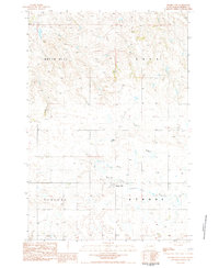
1983 Map of Grandmas Butte
USGS Topo · Published 1984About this map
Grandmas Butte dominates the northeastern corner of this Perkins County landscape, providing a primary landmark in a region defined by its complex drainage systems and open rangeland. The hydrology of the area is centered on Thunder Butte Creek and its tributary, the South Branch Thunder Butte Creek, which carve winding paths across the southern half of the quadrangle. Other smaller watercourses including Murphy Creek and Snake Creek further define the terrain. Evidence of community infrastructure is concentrated around the southern section near the Townhall, while the northern reaches are characterized by the elevations of the Rocky Hills and Wolf Hill. The map also documents numerous scattered wells across the townships of Vail Cash and Strool Scotch Cap, reflecting the essential water-security needs of the local agricultural economy.
Find a feature on this map
11 named features on this map. Tap any name to fly to it.
Don’t see what you’re looking for? This feature index may not catch every label — zoom into the map to look around manually.
Map Details
Editions of this 1983 Grandmas Butte Map
This is the sole edition of this map. No revisions or reprints were ever made.
Other maps of this area

1954 · Lemmon
USGS Topo · 1:250,000

1957 · Lemmon
USGS Topo · 1:250,000

1983 · Prairie City NE
USGS Topo · 1:24,000

1983 · Square Top Butte
USGS Topo · 1:24,000

1983 · Sorum NE
USGS Topo · 1:24,000

1983 · Cole Dam
USGS Topo · 1:24,000

1983 · Date NE
USGS Topo · 1:24,000

1983 · Little Nasty Creek
USGS Topo · 1:24,000

1983 · Daviston
USGS Topo · 1:24,000
1983 · Prairie City
USGS Topo · 1:24,000