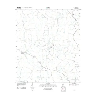
2012 Map of Soso
USGS Topo · Published 2012About this map
The petroleum landscape of Jones and Jasper Counties is clearly defined on this 2012 survey, showing a network of sub-surface resources like the Soso Oil and Gas Field and the Gitano Oil and Gas Field. Small pools, including the Christmas Gas Pool and Rodessa Oil Pool, are interspersed among established timber and agricultural lands. The community of Soso anchors the southern portion of the map, while Stringer sits to the northeast, connected by rural routes such as Co Hwy 17.
Find a feature on this map
130 named features on this map. Tap any name to fly to it.
Don’t see what you’re looking for? This feature index may not catch every label — zoom into the map to look around manually.
Map Details
Editions of this 2012 Soso Map
This is the sole edition of this map. No revisions or reprints were ever made.
Other maps of this area

1953 · Hattiesburg
USGS Topo · 1:250,000

1958 · Hattiesburg
USGS Topo · 1:250,000

1964 · Moss
USGS Topo · 1:24,000

1964 · Laurel West
USGS Topo · 1:24,000

1964 · Lake Como
USGS Topo · 1:24,000

1965 · Hebron
USGS Topo · 1:24,000

1965 · Hot Coffee
USGS Topo · 1:24,000

1974 · Soso
USGS Topo · 1:24,000
1974 · Bay Springs
USGS Topo · 1:24,000

1975 · Taylorsville
USGS Topo · 1:24,000