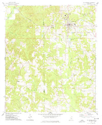
1974 Map of Bay Springs
USGS Topo · Published 1978About this map
Bay Springs serves as the hub of this 1974 landscape, situated at the intersection of local industry and rural community life. The eastern side of the town is marked by the presence of the Bay Springs Oil and Gas Field, complete with its Pumping Station and associated energy infrastructure. This industrial footprint contrasts with the surrounding piney woods and creek bottoms, where a dense network of small rural congregations like Mt Nebo Ch, Blue Mountain Ch, and New Home Ch define the social geography of the era.
Find a feature on this map
43 named features on this map. Tap any name to fly to it.
Don’t see what you’re looking for? This feature index may not catch every label — zoom into the map to look around manually.
Map Details
Editions of this 1974 Bay Springs Map
This is the sole edition of this map. No revisions or reprints were ever made.
Other maps of this area

1953 · Hattiesburg
USGS Topo · 1:250,000

1953 · Meridian
USGS Topo · 1:250,000

1957 · Meridian
USGS Topo · 1:250,000

1958 · Hattiesburg
USGS Topo · 1:250,000

1964 · Moss
USGS Topo · 1:24,000

1964 · Lake Como
USGS Topo · 1:24,000

1965 · Meridian
USGS Topo · 1:250,000

1968 · Louin
USGS Topo · 1:24,000

1968 · Louin SW
USGS Topo · 1:24,000
1970 · Montrose South
USGS Topo · 1:24,000