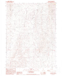
1990 Map of Sou Hills
USGS Topo · Published 1990About this map
Pleasant Valley serves as the central corridor of this survey, a broad desert basin framed by the rising peaks of the East Range and the Tobin Range. In a landscape defined by aridity and isolation, the Paris Ranch stands as a rare outpost of settlement along the course of Spring Creek. The map documents a clear history of mineral exploration throughout the higher elevations, particularly in the northern reaches where numerous Prospects, a Shaft, and an identified Mine suggest a landscape long poked and prodded for potential wealth. The southern portion of the quadrangle is dominated by the Sou Hills, where the intricate contouring reveals a complex network of dry washes and high-desert terrain typical of Pershing County during the late twentieth century.
Find a feature on this map
13 named features on this map. Tap any name to fly to it.
Don’t see what you’re looking for? This feature index may not catch every label — zoom into the map to look around manually.
Map Details
Editions of this 1990 Sou Hills Map
This is the sole edition of this map. No revisions or reprints were ever made.
Other maps of this area

1932 · Sonoma Range
USGS Topo · 1:250,000

1939 · Sonoma Range
USGS Topo · 1:250,000

1955 · Winnemucca
USGS Topo · 1:250,000

1958 · Winnemucca
USGS Topo · 1:250,000
1961 · Kyle Hot Springs
USGS Topo · 1:62,500

1961 · Mt. Tobin
USGS Topo · 1:62,500

1961 · Cain Mountain
USGS Topo · 1:62,500

1961 · Fencemaker
USGS Topo · 1:62,500

1962 · Winnemucca
USGS Topo · 1:250,000

1982 · Fish Creek Mts
USGS Topo · 1:100,000