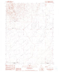
1990 Map of Sou Hot Springs
USGS Topo · Published 1990About this map
Sou Hot Springs and Hyder Hot Springs anchor this arid landscape at the northern reaches of the Dixie Valley. The map reveals a remote pastoral and geothermal environment defined by the Sou Hills and a network of water management features, including several Ditches and a Landing Strip indicative of the area's isolation. Cultural history is marked by the Little Mc Coy Ranch and the Seven Devils Ranch (Site), the latter noted as a historical location rather than an active operation. The drainage patterns of Spring Creek and Jersey Valley Wash illustrate how water moves through this desert basin, while the boundary between Pershing Co and Churchill Co cuts across the southern portion of the survey. This 1990 provisional edition provides a clear record of the specific ranching footprints and natural thermal features that have long drawn interest to this part of the Great Basin.
Find a feature on this map
16 named features on this map. Tap any name to fly to it.
Don’t see what you’re looking for? This feature index may not catch every label — zoom into the map to look around manually.
Map Details
Editions of this 1990 Sou Hot Springs Map
This is the sole edition of this map. No revisions or reprints were ever made.
Other maps of this area

1932 · Sonoma Range
USGS Topo · 1:250,000

1939 · Sonoma Range
USGS Topo · 1:250,000

1955 · Millett
USGS Topo · 1:250,000

1955 · Winnemucca
USGS Topo · 1:250,000

1958 · Winnemucca
USGS Topo · 1:250,000

1959 · Millett
USGS Topo · 1:250,000

1961 · Cain Mountain
USGS Topo · 1:62,500

1961 · Fencemaker
USGS Topo · 1:62,500

1962 · Winnemucca
USGS Topo · 1:250,000

1966 · Humboldt Salt Marsh
USGS Topo · 1:62,500