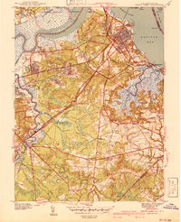
1941 Map of South Amboy
USGS Topo · Published 1941About this map
Raritan Bay and the winding Raritan River define this coastal New Jersey landscape on the eve of the Second World War. The region is a dense network of industrial transit and residential growth, where the Pennsylvania and New York and Long Branch railroads converge at South Amboy. Significant land use includes the U S Military Reservation in the north and the early footprint of Cheesequake State Park. Local communities like Sayreville (Boro), Old Bridge, and Morgan Heights are clearly delineated alongside numerous family and community landmarks. Genealogists will find particular value in the identification of several burial grounds, including the Polish Cem and Beth Israel Cem, as well as numerous local schools such as Wilson Sch and Morristown Sch that served these growing boroughs and townships.
Find a feature on this map
53 named features on this map. Tap any name to fly to it.
Don’t see what you’re looking for? This feature index may not catch every label — zoom into the map to look around manually.
Map Details
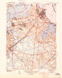
Editions of this 1941 South Amboy Map
2 editions found
Other maps of this area

1888 · Plainfield
USGS Topo · 1:62,500

1888 · New Brunswick
USGS Topo · 1:62,500

1888 · Sandy Hook
USGS Topo · 1:62,500

1893 · New Brunswick
USGS Topo · 1:62,500

1893 · Plainfield
USGS Topo · 1:62,500

1893 · Sandy Hook
USGS Topo · 1:62,500

1898 · Plainfield
USGS Topo · 1:62,500

1898 · Staten Island
USGS Topo · 1:62,500

1900 · Passaic
USGS Topo · 1:125,000

1900 · Staten Island
USGS Topo · 1:62,500