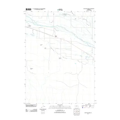
2011 Map of South Bayard
USGS Topo · Published 2011About this map
Chimney Rock stands as a defining landmark south of the North Platte River, serving as a silent witness to the historic paths that cross this Morrill County landscape. This 2011 survey details the intricate irrigation network essential to the region, including the Alliance Canal, Ninemile Canal, and Chimney Rock Canal, which draw from the river to support local agriculture. The map documents the spatial relationship between the settlements of South Bayard and East Bayard, alongside legacy routes like Oregon Trail Rd and the Oregon Trail Wagon Train Campground. Genealogists and local historians can locate the Chimney Rock Cemetery near the base of the namesake spire, while topographical details reveal the carved depths of McManigal Canyon and Bedding Canyon to the south. The presence of Focus Springs and various drains further illustrates the complex water management required in this high plains environment.
Find a feature on this map
20 named features on this map. Tap any name to fly to it.
Don’t see what you’re looking for? This feature index may not catch every label — zoom into the map to look around manually.
Map Details
Editions of this 2011 South Bayard Map
This is the sole edition of this map. No revisions or reprints were ever made.
Other maps of this area

1898 · Camp Clarke
USGS Topo · 1:125,000

1954 · Scottsbluff
USGS Topo · 1:250,000

1958 · Scottsbluff
USGS Topo · 1:250,000

1965 · Bayard
USGS Topo · 1:24,000

1965 · Bridgeport NW
USGS Topo · 1:24,000

1965 · South Bayard
USGS Topo · 1:24,000

1965 · Bayard SW
USGS Topo · 1:24,000
1965 · Angora
USGS Topo · 1:24,000

1965 · McGrew
USGS Topo · 1:24,000

1973 · Bridgeport SW
USGS Topo · 1:24,000