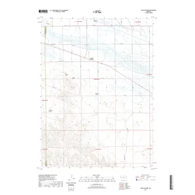
2017 Map of South Bayard
USGS Topo · Published 2017About this map
Chimney Rock rises as a prominent landmark south of the North Platte River, serving as a silent witness to the westward migration route marked by Oregon Trail Rd. This landscape in Morrill County is defined by its sophisticated irrigation network, where the Alliance Canal, Ninemile Canal, and Chimney Rock Canal redirect water across the valley to support local agriculture. The twin settlements of Bayard and South Bayard anchor the northern portion of the map, while the terrain to the south becomes increasingly complex with features like Bedding Canyon and McManigal Canyon. Local history is preserved at the Chimney Rock Cem, situated just below the iconic spire. The map also captures several natural water sources and drainage systems, including Fucus Springs and the Wildhorse Drain, which emphasize the critical role of water management in this high-plains environment.
Find a feature on this map
34 named features on this map. Tap any name to fly to it.
Don’t see what you’re looking for? This feature index may not catch every label — zoom into the map to look around manually.
Map Details
Editions of this 2017 South Bayard Map
This is the sole edition of this map. No revisions or reprints were ever made.
Other maps of this area

1898 · Camp Clarke
USGS Topo · 1:125,000

1954 · Scottsbluff
USGS Topo · 1:250,000

1958 · Scottsbluff
USGS Topo · 1:250,000

1965 · Bayard
USGS Topo · 1:24,000

1965 · Bridgeport NW
USGS Topo · 1:24,000

1965 · South Bayard
USGS Topo · 1:24,000

1965 · Bayard SW
USGS Topo · 1:24,000
1965 · Angora
USGS Topo · 1:24,000

1965 · McGrew
USGS Topo · 1:24,000

1973 · Bridgeport SW
USGS Topo · 1:24,000