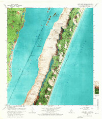
1969 Map of South Bird Island
USGS Topo · Published 1970About this map
Padre Island National Seashore is captured here as an expansive orthophotomap, showing the dynamic intersection of shifting sands and coastal waters during the late 1960s. The terrain is dominated by shifting sand dunes that reach up to 28 feet in height, separating the shallow Laguna Madre from the open Gulf of Mexico. On the western shore, the remnants of ranching and early aviation are visible in the Lobo Windmill, Novilla Windmill, and the inactive Outlying Field 42. Development on the island is concentrated at the Malaquite Beach Development, while the South Bird Island Nesting Area highlights the region's importance as a protected habitat. Navigational features like the Intracoastal Waterway and various beacons mark the transit routes used by coastal mariners of the era.
Find a feature on this map
28 named features on this map. Tap any name to fly to it.
Don’t see what you’re looking for? This feature index may not catch every label — zoom into the map to look around manually.
Map Details
Editions of this 1969 South Bird Island Map
This is the sole edition of this map. No revisions or reprints were ever made.
Other maps of this area

1925 · Oso Creek
USGS Topo · 1:62,500

1950 · Corpus Christi
USGS Topo · 1:250,000

1951 · South Bird Island
USGS Topo · 1:24,000

1951 · South Bird Island SE
USGS Topo · 1:24,000

1951 · South Bird Island NW
USGS Topo · 1:24,000

1951 · Point Of Rocks
USGS Topo · 1:24,000

1951 · Crane Islands SW
USGS Topo · 1:24,000

1951 · Oso Creek
USGS Topo · 1:62,500

1951 · Crane Islands
USGS Topo · 1:62,500

1951 · South Bird Island
USGS Topo · 1:62,500