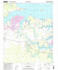
2000 Map of South Creek
USGS Topo · Published 2001About this map
South Creek flows northward into the Pamlico River, defining a coastal landscape where water and land are intimately intertwined. The shoreline is punctuated by numerous family-named points and inlets, such as Tuthill Pt and Hickory Point, reflecting a history of small-scale maritime activity. A Marine Railway near the settlement of South Creek underscores the local reliance on watercraft for transport and trade. Inland, the map reveals a community centered around faith and forestry, with St Kets Church, Shady Grove Ch, and Reads Chapel serving as local landmarks. The eastern portion is dominated by the Goose Creek State Game Land, which preserves the extensive marshy "guts" and prongs like Tetterton Gut and Northeast Prong. The presence of small docks at Alliance Ldg and Wood Landing illustrates the persistence of traditional river access in Beaufort County.
Find a feature on this map
85 named features on this map. Tap any name to fly to it.
Don’t see what you’re looking for? This feature index may not catch every label — zoom into the map to look around manually.
Map Details
Editions of this 2000 South Creek Map
This is the sole edition of this map. No revisions or reprints were ever made.
Other maps of this area

1950 · Vandemere
USGS Topo · 1:24,000

1950 · Lowland
USGS Topo · 1:24,000

1950 · South Creek
USGS Topo · 1:24,000

1950 · Jones Bay
USGS Topo · 1:24,000

1950 · Aurora
USGS Topo · 1:24,000

1951 · Bath
USGS Topo · 1:24,000

1951 · Ransomville
USGS Topo · 1:24,000

1951 · Pamlico Beach
USGS Topo · 1:24,000

1953 · Rocky Mount
USGS Topo · 1:250,000

1954 · Rocky Mount
USGS Topo · 1:250,000