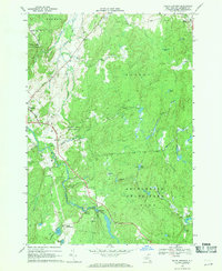
1969 Map of South Edwards
USGS Topo · Published 1971About this map
The Oswegatchie River defines the western corridor of this landscape, winding southward past the village of Edwards and the riverside South Edwards. This 1969 survey reveals a region heavily integrated with state-managed lands, including the Adirondack State Park boundary in the southeast and the Trout Lake State Forest to the northwest. Industry and infrastructure are evident along the river's path, most notably at the Powerplant and several Gravel Pits that supported local development.
Find a feature on this map
43 named features on this map. Tap any name to fly to it.
Don’t see what you’re looking for? This feature index may not catch every label — zoom into the map to look around manually.
Map Details
Editions of this 1969 South Edwards Map
2 editions found
Other maps of this area

1913 · Lake Bonaparte
USGS Topo · 1:62,500

1915 · Gouverneur
USGS Topo · 1:62,500

1915 · Russell
USGS Topo · 1:62,500

1916 · Lake Bonaparte
USGS Topo · 1:62,500

1916 · Oswegatchie
USGS Topo · 1:62,500

1918 · Russell
USGS Topo · 1:62,500

1918 · Oswegatchie
USGS Topo · 1:62,500

1937 · Gouverneur
USGS Topo · 1:62,500

1948 · Ogdensburg
USGS Topo · 1:250,000

1951 · Ogdensburg
USGS Topo · 1:250,000