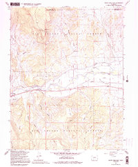
1967 Map of South Fork East
USGS Topo · Published 1992About this map
South Fork Rio Grande and the main stem of the Rio Grande River meet in a landscape defined by ranching and water management within the Rio Grande National Forest. The 1960s terrain shows a complex irrigation network vital to the valley, including the Anaconda Ditch, Highline Ditch, and Minor Ditch. Small settlements like Gerrard, Alpine, and Granger dot the river corridor, while the Holy Family Mission and a small Cem near Agua Ramon Creek provide evidence of the area's social and spiritual foundations.
Find a feature on this map
40 named features on this map. Tap any name to fly to it.
Don’t see what you’re looking for? This feature index may not catch every label — zoom into the map to look around manually.
Map Details
Editions of this 1967 South Fork East Map
3 editions found
Other maps of this area

1914 · Creede
USGS Topo · 1:125,000

1915 · Del Norte
USGS Topo · 1:125,000

1916 · Creede
USGS Topo · 1:125,000

1917 · Del Norte
USGS Topo · 1:125,000

1945 · Durango
USGS Topo · 1:250,000

1953 · Durango
USGS Topo · 1:250,000

1954 · Durango
USGS Topo · 1:250,000

1961 · Durango
USGS Topo · 1:250,000

1963 · Durango
USGS Topo · 1:250,000

1966 · Durango
USGS Topo · 1:250,000