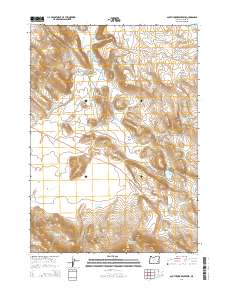
2014 Map of South Fork Reservoir
USGS Topo · Published 2014About this map
The South Fork Malheur River flows through this high-desert landscape in Harney County, defined by a sophisticated system of water management. Numerous reservoirs, including Dewdrop Reservoir, Jewell Reservoir, and the South Fork Reservoir, are distributed across the drainage basins of Indian Cr and Camp Cr. This network of catchments and the South Fork Waterhole suggest a landscape deeply integrated with livestock ranching and arid-land hydrology.
Find a feature on this map
36 named features on this map. Tap any name to fly to it.
Don’t see what you’re looking for? This feature index may not catch every label — zoom into the map to look around manually.
Map Details
Editions of this 2014 South Fork Reservoir Map
This is the sole edition of this map. No revisions or reprints were ever made.
Other maps of this area

1955 · Burns
USGS Topo · 1:250,000

1958 · Burns
USGS Topo · 1:250,000

1959 · Burns
USGS Topo · 1:250,000

1968 · Venator
USGS Topo · 1:62,500
1972 · Stockade Mtn
USGS Topo · 1:62,500

1972 · Circle Bar
USGS Topo · 1:24,000
1972 · Venator Reservoir
USGS Topo · 1:24,000

1972 · Venator
USGS Topo · 1:24,000

1974 · Anderson Mtn
USGS Topo · 1:62,500
1974 · Folly Farm
USGS Topo · 1:24,000