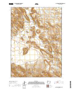
2020 Map of South Fork Reservoir
USGS Topo · Published 2020About this map
The S Fork Malheur River winds through this high desert region of Harney County, defining a landscape shaped by water management and ranching infrastructure. Arid basins and volcanic features like Red Mtn are surrounded by an extensive network of small-scale impoundments, including Red Hen Reservoir, Jewell Reservoir, and the South Fork Waterhole. This reliance on collected water is further evidenced by the Browns Feed Canal leading into Browns Reservoir. Transportation across this remote terrain is anchored by Crane Blvd, which intersects with local ranching routes such as Malheur Cave Rd and Norman Ranch RD. From the heights of Barren Valley to the lowlands of Big Gulch, the map reveals a modern ranching environment where every drainage is utilized for livestock and land management.
Find a feature on this map
36 named features on this map. Tap any name to fly to it.
Don’t see what you’re looking for? This feature index may not catch every label — zoom into the map to look around manually.
Map Details
Editions of this 2020 South Fork Reservoir Map
This is the sole edition of this map. No revisions or reprints were ever made.
Other maps of this area

1955 · Burns
USGS Topo · 1:250,000

1958 · Burns
USGS Topo · 1:250,000

1959 · Burns
USGS Topo · 1:250,000

1968 · Venator
USGS Topo · 1:62,500
1972 · Stockade Mtn
USGS Topo · 1:62,500

1972 · Circle Bar
USGS Topo · 1:24,000
1972 · Venator Reservoir
USGS Topo · 1:24,000

1972 · Venator
USGS Topo · 1:24,000

1974 · Anderson Mtn
USGS Topo · 1:62,500
1974 · Folly Farm
USGS Topo · 1:24,000