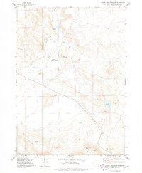
1977 Map of South Fork Reservoir
USGS Topo · Published 1978About this map
Malheur Cave stands as a primary landmark in this high desert landscape of eastern Oregon, situated near the upper reaches of the Malheur River. The topography of the late 1970s is defined by a sophisticated network of small-scale water management features, including the South Fork Reservoir and numerous smaller catchments like Browns Reservoir 4182, Red Mountain Reservoir, and Pollock Draw Reservoir. These scattered water sources underscore the necessity of water storage for ranching or land use in this arid environment.
Find a feature on this map
17 named features on this map. Tap any name to fly to it.
Don’t see what you’re looking for? This feature index may not catch every label — zoom into the map to look around manually.
Map Details
Editions of this 1977 South Fork Reservoir Map
This is the sole edition of this map. No revisions or reprints were ever made.
Other maps of this area

1955 · Burns
USGS Topo · 1:250,000

1958 · Burns
USGS Topo · 1:250,000

1959 · Burns
USGS Topo · 1:250,000

1968 · Venator
USGS Topo · 1:62,500
1972 · Stockade Mtn
USGS Topo · 1:62,500

1972 · Circle Bar
USGS Topo · 1:24,000
1972 · Venator Reservoir
USGS Topo · 1:24,000

1972 · Venator
USGS Topo · 1:24,000

1974 · Anderson Mtn
USGS Topo · 1:62,500
1974 · Folly Farm
USGS Topo · 1:24,000