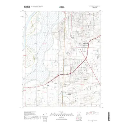
2020 Map of South Fort Smith
USGS Topo · Published 2020About this map
The Arkansas River and Poteau River define the northern and western reaches of this borderland survey, where the Oklahoma-Arkansas state line bisects the urban growth of Fort Smith. The terrain shifts from the river bottomlands into a series of prominent rises including Brooks Stephens Mtn, George Mtn, and White Bluff Mtn, creating a complex landscape of residential neighborhoods and industrial corridors. Infrastructure like the Kansas City Southern Ry and Folsom Blvd connects established settlements such as Arkoma, Pocola, and Cavanaugh. Genealogists will find numerous burial sites noted throughout the area, including Oak Cem, White Bluff Cem, and the uniquely named 34eard Cem. This detailed view of the South Fort Smith area illustrates the modern density of the region while preserving the locations of smaller communities like Enterprise and Cedars along the state boundary.
Find a feature on this map
171 named features on this map. Tap any name to fly to it.
Don’t see what you’re looking for? This feature index may not catch every label — zoom into the map to look around manually.
Map Details
Editions of this 2020 South Fort Smith Map
This is the sole edition of this map. No revisions or reprints were ever made.
Other maps of this area

1879 · Fort Smith
USGS Topo · 1:62,500

1887 · Van Buren
USGS Topo · 1:62,500

1887 · Greenwood
USGS Topo · 1:62,500

1890 · Fort Smith
USGS Topo · 1:125,000

1900 · Sallisaw
USGS Topo · 1:125,000

1911 · Sallisaw
USGS Topo · 1:125,000

1943 · Fort Smith
USGS Topo · 1:125,000

1946 · Fort Smith
USGS Topo · 1:250,000

1947 · Van Buren
USGS Topo · 1:62,500

1947 · Greenwood
USGS Topo · 1:62,500