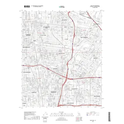
2018 Map of South Gate
USGS Topo · Published 2018About this map
The Los Angeles River and Rio Hondo converge in this densely developed corridor of Los Angeles County, anchoring a landscape defined by industrial centers and historic residential communities. Major transportation arteries like the Imperial Hwy and Rosecrans Ave bisect a network of cities including South Gate, Lynwood, and Paramount. The map reveals a high concentration of memorial sites in the northeast, such as the Russian Molokan Cem and Mount Olive Memorial Park Jewish Cem, which speak to the area's diverse cultural heritage. Further south, the infrastructure of the mid-20th century aviation and education sectors is visible at the Compton/Woodley Airport and the Charles Drew Univ of Medicine and Science. This survey documents the transition from the river-bottom lands to a fully integrated urban grid, where older districts like Willowbrook and Walnut Park maintain their distinct boundaries amidst the surrounding expansion.
Find a feature on this map
52 named features on this map. Tap any name to fly to it.
Don’t see what you’re looking for? This feature index may not catch every label — zoom into the map to look around manually.
Map Details
Editions of this 2018 South Gate Map
This is the sole edition of this map. No revisions or reprints were ever made.
Other maps of this area

1894 · Los Angeles
USGS Topo · 1:62,500

1896 · Pasadena
USGS Topo · 1:62,500

1896 · Redondo
USGS Topo · 1:62,500

1896 · Santa Monica
USGS Topo · 1:62,500

1896 · Downey
USGS Topo · 1:62,500

1898 · Santa Monica
USGS Topo · 1:62,500

1899 · Downey
USGS Topo · 1:62,500

1900 · Pasadena
USGS Topo · 1:62,500

1900 · Los Angeles
USGS Topo · 1:62,500

1901 · Southern California Sheet No. 1
USGS Topo · 1:250,000