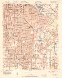
1952 Map of South gate
USGS Topo · Published 1952About this map
The industrial and residential expansion of the Los Angeles basin is captured here in the early postwar period. A dense network of rail lines, including the Southern Pacific, Union Pacific, and the iconic Pacific Electric, connects industrial hubs like Vernon and South Gate to the rest of the region. The landscape is a mix of rapidly growing residential grids and heavy industry, evidenced by the numerous Oil Refineries and the Military Reservation situated near the confluence of the Los Angeles River and the Rio Hondo. Local social infrastructure is well-established, with dozens of neighborhood schools such as Loma Vista Ave Sch and healthcare centers like St Francis Hosp serving these rising communities. Smaller, perhaps lesser-known settlements like Vinvale, Simons, and Rendalia appear alongside established cities, providing a record of the area's development before it fully merged into a contiguous urban expanse.
Find a feature on this map
81 named features on this map. Tap any name to fly to it.
Don’t see what you’re looking for? This feature index may not catch every label — zoom into the map to look around manually.
Map Details
Editions of this 1952 South gate Map
This is the sole edition of this map. No revisions or reprints were ever made.
Other maps of this area

1894 · Los Angeles
USGS Topo · 1:62,500

1896 · Pasadena
USGS Topo · 1:62,500

1896 · Redondo
USGS Topo · 1:62,500

1896 · Santa Monica
USGS Topo · 1:62,500

1896 · Downey
USGS Topo · 1:62,500

1898 · Santa Monica
USGS Topo · 1:62,500

1899 · Downey
USGS Topo · 1:62,500

1900 · Pasadena
USGS Topo · 1:62,500

1900 · Los Angeles
USGS Topo · 1:62,500

1901 · Southern California Sheet No. 1
USGS Topo · 1:250,000