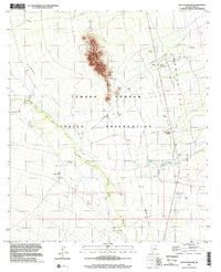
1996 Map of South Komelik
USGS Topo · Published 2002About this map
Aguirre Peak rises dramatically from the desert floor within the Tohono O'odham Indian Reservation, serving as a central vertical landmark in a landscape defined by seasonal watercourses. The drainage patterns of Vamori Wash and Chutum Vaya Wash dictate the layout of the region, where small settlements and community points like South Komelik and Choulic are situated. This mid-1990s record captures the desert infrastructure of the Baboquivari Valley, showing the proximity of tribal villages such as Supi Oidak (Goldfield) and San Miguel to the international border. The presence of several cemeteries and the Ak Chut Vaya settlement provide valuable data for genealogists and those studying the spatial history of the Tohono O'odham people.
Find a feature on this map
13 named features on this map. Tap any name to fly to it.
Don’t see what you’re looking for? This feature index may not catch every label — zoom into the map to look around manually.
Map Details
Editions of this 1996 South Komelik Map
This is the sole edition of this map. No revisions or reprints were ever made.
Other maps of this area

1941 · Presumido Peak
USGS Topo · 1:62,500

1941 · Baboquivari Peak
USGS Topo · 1:62,500

1941 · Vamori
USGS Topo · 1:62,500

1941 · Sells
USGS Topo · 1:62,500

1943 · Sells
USGS Topo · 1:62,500

1943 · Fresnal
USGS Topo · 1:125,000

1943 · Presumido Peak
USGS Topo · 1:62,500

1943 · Vamori
USGS Topo · 1:62,500

1944 · Baboquivari Peak
USGS Topo · 1:62,500

1956 · Nogales
USGS Topo · 1:250,000
Featured Places
- Topawa, AZ
- Chukut Kuk District, AZ
- Choulic, Topawa
- South Komelik, Topawa
- Ak Chut Vaya, Chukut Kuk District