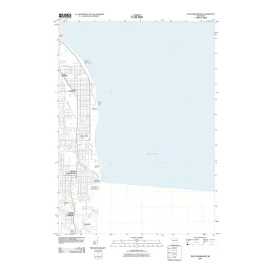
2010 Map of South Milwaukee
USGS Topo · Published 2010About this map
The Lake Michigan shoreline dominates this 2010 topographic profile of Milwaukee County's industrial and residential lakefront. The map documents the established municipal boundaries of Saint Francis, Cudahy, and South Milwaukee, extending south to the historic industrial district of Carrollville in Oak Creek. This era shows a landscape defined by significant infrastructure and recreational land use, ranging from the Wisconsin Electric Power Company facilities to the expansive greens of Warnimont Golf Course and Grant Park Golf Course. Genealogy and local history researchers can identify specific burial grounds such as Holy Sepulchre Cemetery, Agudas Achim Cemetery, and Saint Matthews Cemetery. The map also captures the essential municipal services along the coast, including the Cudahy Water Works and the South Milwaukee Wastewater Treatment Facility, reflecting the intensive urban development of the Milwaukee south shore.
Find a feature on this map
24 named features on this map. Tap any name to fly to it.
Don’t see what you’re looking for? This feature index may not catch every label — zoom into the map to look around manually.
Map Details
Editions of this 2010 South Milwaukee Map
This is the sole edition of this map. No revisions or reprints were ever made.
Other maps of this area

1891 · Bayview
USGS Topo · 1:62,500

1892 · Milwaukee
USGS Topo · 1:62,500

1901 · Milwaukee
USGS Topo · 1:62,500

1901 · Bayview
USGS Topo · 1:62,500

1906 · Milwaukee
USGS Topo · 1:62,500

1954 · Milwaukee
USGS Topo · 1:250,000

1958 · Milwaukee
USGS Topo · 1:250,000
1958 · Milwaukee
USGS Topo · 1:24,000
1958 · Racine North
USGS Topo · 1:24,000
1958 · Milwaukee
USGS Topo · 1:62,500