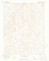
1964 Map of South Mountain
USGS Topo · Published 1968About this map
South Mountain and the surrounding Dolores County high country are mapped here during a period of minimal infrastructure, characterized by high mesas and deep drainage basins. The northern reach is dominated by the winding path of Disappointment Creek, which is fed by numerous seasonal waterways including Alkali Wash and Warden Draw. Evidence of early settlement and land use appears in the form of the Nash Cem and remote water sources like Browning Spring, essential for ranching and survival in this arid environment.
Find a feature on this map
21 named features on this map. Tap any name to fly to it.
Don’t see what you’re looking for? This feature index may not catch every label — zoom into the map to look around manually.
Map Details
Editions of this 1964 South Mountain Map
3 editions found
Other maps of this area

1956 · Cortez
USGS Topo · 1:250,000

1958 · Cortez
USGS Topo · 1:250,000

1959 · Cortez
USGS Topo · 1:250,000

1962 · Cortez
USGS Topo · 1:250,000
1963 · Nipple Mountain
USGS Topo · 1:24,000
1964 · Groundhog Reservoir
USGS Topo · 1:24,000
1964 · Lone Cone
USGS Topo · 1:24,000

1964 · Glade Mountain
USGS Topo · 1:24,000
1964 · North Mountain
USGS Topo · 1:24,000

1964 · Mc Kenna Peak
USGS Topo · 1:24,000