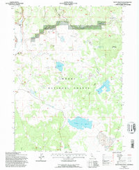
1993 Map of South Mountain
USGS Topo · Published 1996About this map
Modoc National Forest encompasses this high-elevation landscape, where seasonal water management and ranching history define the terrain. The presence of the Mulkey Place (Site) near Spring and Willow Creek Ranch suggests the localized agricultural activity common in this region during the late twentieth century. A sophisticated network of water storage, including Telephone Flat Reservoir, South Mtn Reservoir, and the Deer Hill Reservoir, dots the volcanic landscape to support livestock and forest health. Notable topographic features such as South Mountain, Deer Hill, and the elongated Juniper Ridge organize the drainage patterns for Fletcher Creek and Willow Creek. The map also captures numerous localized watering spots like Cow Head Tank and Cougar Pass Tank, connected by a web of 4WD trails that navigate the numerous Dry Lakes scattered across the plateau.
Find a feature on this map
43 named features on this map. Tap any name to fly to it.
Don’t see what you’re looking for? This feature index may not catch every label — zoom into the map to look around manually.
Map Details
Editions of this 1993 South Mountain Map
This is the sole edition of this map. No revisions or reprints were ever made.
Other maps of this area

1886 · Alturas
USGS Topo · 1:250,000

1892 · Alturas
USGS Topo · 1:250,000

1954 · Alturas
USGS Topo · 1:250,000

1958 · Alturas
USGS Topo · 1:250,000

1962 · Alturas
USGS Topo · 1:250,000

1962 · Big Sage Reservoir
USGS Topo · 1:62,500

1962 · Steele Swamp
USGS Topo · 1:62,500

1962 · South Mountain
USGS Topo · 1:62,500

1962 · Jacks Butte
USGS Topo · 1:62,500

1965 · Alturas
USGS Topo · 1:250,000