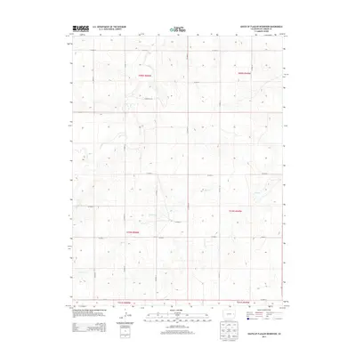
2013 Map of South of Flagler Reservoir
USGS Topo · Published 2013About this map
High plains topography and the systematic geometry of rural infrastructure define this portion of Kit Carson County south of the interstate corridor. The landscape is primarily shaped by the intermittent drainage patterns of Sand Cr and Spring Cr, which meander through a series of gently sloping draws and basins. These natural watercourses provide a striking contrast to the rigid Public Land Survey System grid that organizes the territory into distinct townships and ranges. A dense network of local routes, including CO Road 12, CO Road 10, and CO Road 9, follows these section lines, revealing the deliberate planning of Colorado’s agricultural frontier. For those researching the history of the eastern plains, the map offers a clear view of the relationship between early 21st-century road development and the underlying terrain.
Find a feature on this map
23 named features on this map. Tap any name to fly to it.
Don’t see what you’re looking for? This feature index may not catch every label — zoom into the map to look around manually.
Map Details
Editions of this 2013 South of Flagler Reservoir Map
This is the sole edition of this map. No revisions or reprints were ever made.
Other maps of this area

1954 · Limon
USGS Topo · 1:250,000

1957 · Limon
USGS Topo · 1:250,000

1958 · Limon
USGS Topo · 1:250,000

1979 · Stratton 3 SE
USGS Topo · 1:24,000

1979 · Hugo 4 NE
USGS Topo · 1:24,000

1979 · Flagler
USGS Topo · 1:24,000
1979 · Hugo 4 SE
USGS Topo · 1:24,000
1979 · Stratton 3 SW
USGS Topo · 1:24,000

1979 · Stratton 3 NE
USGS Topo · 1:24,000
1979 · South of Flagler Reservoir
USGS Topo · 1:24,000