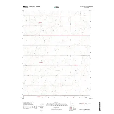
2019 Map of South of Flagler Reservoir
USGS Topo · Published 2019About this map
The high plains south of the town of Flagler in Kit Carson County are defined by a network of seasonal watercourses and a rigid grid of rural roads. The landscape is dominated by the drainages of Sand Cr and Spring Cr, which carve subtle topography through the open agricultural and grazing lands of the eastern Colorado plains. This survey captures the rural infrastructure at the end of the second decade of the 21st century, showing the precise layout of county corridors such as Co Rd R and Co Rd G. The map detail highlights the Public Land Survey System divisions, including portions of t10s r50w and t10s r49w, providing a clear view of the property boundaries and section lines that have shaped the region's ranching and farming history since settlement.
Find a feature on this map
22 named features on this map. Tap any name to fly to it.
Don’t see what you’re looking for? This feature index may not catch every label — zoom into the map to look around manually.
Map Details
Editions of this 2019 South of Flagler Reservoir Map
This is the sole edition of this map. No revisions or reprints were ever made.
Other maps of this area

1954 · Limon
USGS Topo · 1:250,000

1957 · Limon
USGS Topo · 1:250,000

1958 · Limon
USGS Topo · 1:250,000

1979 · Stratton 3 SE
USGS Topo · 1:24,000

1979 · Hugo 4 NE
USGS Topo · 1:24,000

1979 · Flagler
USGS Topo · 1:24,000
1979 · Hugo 4 SE
USGS Topo · 1:24,000
1979 · Stratton 3 SW
USGS Topo · 1:24,000

1979 · Stratton 3 NE
USGS Topo · 1:24,000
1979 · South of Flagler Reservoir
USGS Topo · 1:24,000