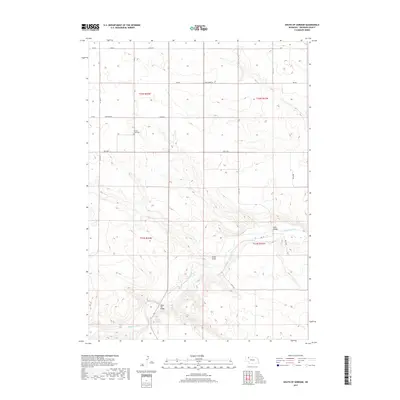
2017 Map of South of Gordon
USGS Topo · Published 2017About this map
The Niobrara River winds through this section of Sheridan County, carving a valley defined by prominent drainages like Sand Draw. The landscape is a network of rural section lines and access trails, reflecting the enduring ranching and agricultural character of the Nebraska Panhandle. To the south, the river is spanned by the Mills Bridge and the Eddie Hill Bridge, providing essential crossings in a region where the water and topography dictate the flow of travel. Further north, the Mount Hope Cem sits along Cemetery Rd, serving as a quiet focal point for the surrounding homesteads. Water management is evidenced by the Leach Reservoir, while a grid of numbered routes such as Pole Creek Rd and 600 Rd connect the isolated ranch buildings across the plains.
Find a feature on this map
30 named features on this map. Tap any name to fly to it.
Don’t see what you’re looking for? This feature index may not catch every label — zoom into the map to look around manually.
Map Details
Editions of this 2017 South of Gordon Map
This is the sole edition of this map. No revisions or reprints were ever made.
Other maps of this area

1955 · Alliance
USGS Topo · 1:250,000

1957 · Alliance
USGS Topo · 1:250,000

1958 · Alliance
USGS Topo · 1:250,000

1969 · Rushville 4 SW
USGS Topo · 1:24,000

1969 · Gordon
USGS Topo · 1:24,000
1969 · Gordon SE
USGS Topo · 1:24,000

1969 · Clinton
USGS Topo · 1:24,000

1969 · Rushville SE
USGS Topo · 1:24,000
1969 · Rushville 4 NE
USGS Topo · 1:24,000
1969 · Rushville 4 NW
USGS Topo · 1:24,000