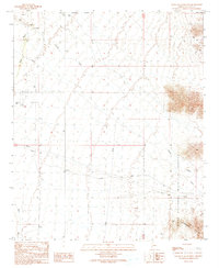
1990 Map of South of Quartzsite
USGS Topo · Published 1990About this map
Petroglyphs located in the northwestern reaches of this desert terrain hint at ancient history in a landscape otherwise defined by utility and wildlife preservation. The southern extent of the Quartzsite Corporate Boundary marks the transition from town limits into a high-desert expanse where the Kofa National Wildlife Refuge protects the rugged Livingston Hills. Resource extraction and infrastructure dominate the lower flats, evidenced by numerous Prospects and a network of pipelines and transmission lines that cut across the drainage of Tyson Wash and French Creek. Local habitation is concentrated around the Trailer Park and Eightmile Well, providing a look at rural Arizona settlement patterns just before the turn of the millennium. The network of 4wd tracks and the presence of Blevens Road indicate the remote nature of travel and access through these arid basins.
Find a feature on this map
17 named features on this map. Tap any name to fly to it.
Don’t see what you’re looking for? This feature index may not catch every label — zoom into the map to look around manually.
Map Details
Editions of this 1990 South of Quartzsite Map
This is the sole edition of this map. No revisions or reprints were ever made.
Other maps of this area

1933 · Cunningham Mtn
USGS Topo · 1:48,000

1934 · Trigo Peaks
USGS Topo · 1:48,000

1939 · Trigo Peaks
USGS Topo · 1:62,500

1940 · Dome Rock Mts
USGS Topo · 1:62,500

1942 · Blythe
USGS Topo · 1:250,000

1954 · Salton Sea
USGS Topo · 1:250,000

1954 · Trigo Peaks
USGS Topo · 1:62,500

1955 · Salton Sea
USGS Topo · 1:250,000

1959 · Salton Sea
USGS Topo · 1:250,000

1962 · Quartzsite
USGS Topo · 1:62,500