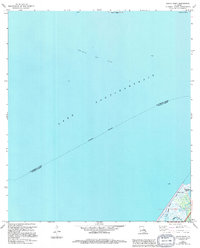
1967 Map of South Point
USGS Topo · Published 1994About this map
Lake Pontchartrain dominates this coastal survey, where the aquatic boundary between St Tammany Parish and Orleans Parish runs through the open water. The map documents an era of offshore extraction, centered on the Big Point Gas Field and its related infrastructure. Along the northern shoreline, coastal geography is defined by Point Platte and Point du Chien, while the southeastern corner reveals a more intricate landscape of wetlands and inlets. Here, the settlement of South Point sits near the marshes of Irish Bayou Lagoon, providing a detailed look at the interface between the tidal waters of Little Cane Bayou and Bayou Castiglione. The inclusion of updated data from the late 1980s reveals the shifting nature of these wetlands at the edge of the New Orleans metropolitan area.
Find a feature on this map
11 named features on this map. Tap any name to fly to it.
Don’t see what you’re looking for? This feature index may not catch every label — zoom into the map to look around manually.
Map Details
Editions of this 1967 South Point Map
3 editions found
Other maps of this area

1891 · Spanish Fort
USGS Topo · 1:62,500

1892 · Chef Menteur
USGS Topo · 1:62,500

1935 · Slidell
USGS Topo · 1:62,500

1935 · Covington
USGS Topo · 1:62,500

1936 · North Shore
USGS Topo · 1:31,680

1936 · South Point
USGS Topo · 1:31,680

1936 · Chef Menteur
USGS Topo · 1:62,500

1936 · Spanish Fort
USGS Topo · 1:62,500

1937 · Chef Menteur
USGS Topo · 1:31,680

1938 · Little Woods
USGS Topo · 1:31,680